

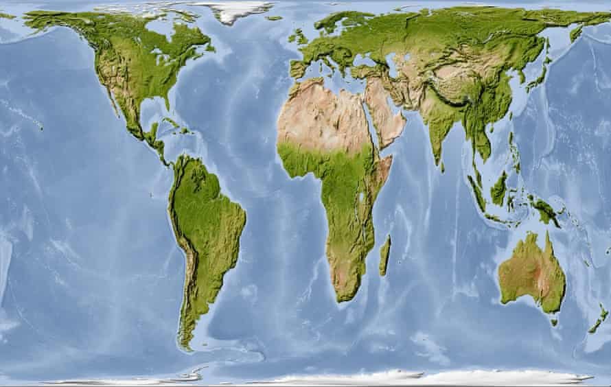
The United Nations General Assembly is expected to vote on Friday on a resolution calling for the gradual replacement of the widely used Mercator world map with a projection that more accurately represents the true size of Africa and other regions.
The initiative is being led by Togo, with Foreign Affairs Minister Robert Dussey saying it has received support from the African Union’s member states.
“This discussion is not a political discussion but a scientific discussion, because there is scientific proof so we all have to accept the reality,” Dussey said.
Although UN resolutions are not legally binding, supporters believe a successful vote could encourage changes in school curricula, digital mapping platforms and other areas where the Mercator projection is commonly used.
Created by Flemish cartographer Gerardus Mercator in 1569, the projection was originally designed to assist sailors with navigation. It has, however, remained widely used despite its significant distortion of the size of countries and continents.

The Mercator projection makes areas close to the equator appear considerably smaller while enlarging regions closer to the poles. One of the clearest examples is Africa and Greenland: although they appear roughly similar in size on the map, Africa is actually about 14 times larger than Greenland.
The #CorrectTheMap campaign has highlighted the distortion, noting in a change.org petition that “You could fit the United States, China, India, Japan, Mexico and much of Europe into Africa and still have land to spare.”
The campaign was endorsed by the African Union in August 2025, after which Togo was asked to lead efforts to promote its adoption internationally.
Critics of the Mercator projection, including historians and geographers, have argued that the map reflects long-standing Western perspectives. Activists have described the continued use of such distorted representations as “cartographic colonialism”.
They argue that the projection has contributed to an exaggerated visual representation of countries in the Northern Hemisphere while making equatorial regions, particularly Africa, appear smaller than they really are.

German historian Arno Peters was among the prominent critics of the Mercator projection. In 1973, he introduced the Peters world map, based on the Gall Peters projection, as an alternative designed to represent countries according to their actual land areas.
Togo’s #CorrectTheMap campaign is instead advocating for the 2018 Equal Earth projection, developed by an international group of cartographers. The projection is designed to preserve the relative sizes of land areas more accurately.
Supporters believe adopting the Equal Earth map could help correct misconceptions about Africa and contribute to efforts to make educational materials and global representations less influenced by colonial-era perspectives.
JJ Enoch, a London-based senior associate at geopolitical risk advisory firm JS Held, said the Mercator projection had contributed to the visual underrepresentation of Africa.
He linked the campaign to efforts by African countries to gain “greater influence in global institutions and greater control over how the continent is represented”.

“Adopting an equal-area map would provide a more accurate basis for education and public understanding, while signalling that Africa’s demographic, economic and geopolitical importance should no longer be viewed through inherited and distorted conventions,” Enoch said.
Togolese officials are hopeful that the resolution will receive strong backing, following the success of another African Union-supported initiative at the UN earlier this year.
In March, a Ghana-sponsored resolution seeking to recognise the transatlantic slave trade as the “gravest crime against humanity” was adopted after 123 countries voted in favour. Three countries opposed it, while 52 abstained.
The outcome has strengthened expectations among supporters of the map initiative that the Togo-led resolution could also secure broad international support.
If approved, the Togolese government plans to organise an implementation event in Lomé during the first quarter of next year, in collaboration with UNESCO, the African Union and technology companies including Google Maps.
Explaining the timing of the campaign, Dussey said: “To those who say why now, I say, why not? When we look at the world map … it is time for us to change the narrative.”
He added, “It’s time for us in Africa to take responsibility to change what we can change ourselves.”
By: Prince Martey-Sogar